Hiking Near Mostar: Velež, Prenj And Podveležje
Mostar sits in a dry karst bowl ringed by hills, and the walking starts at the edge of town: Hum rises straight above the Old Bridge, Fortica sits on its shoulder, and the Velež massif and the Podveležje plateau stretch east into high herb-scented country.
Hiking near Mostar means one steep city-side climb (Hum, on the north bank of the Neretva), viewpoint walks at Fortica, and bigger mountain days on Velež and the Podveležje plateau east of the city. Walk early: ERA5 reanalysis, 1991-2020 puts July and August mean daily highs near 30 C, water is scarce on karst, and mine-suspected areas mean staying on marked paths.
Mostar sits low in a karst valley on the Neretva, ringed by bare limestone hills that turn white in the afternoon sun. The walking starts inside the city itself: Hum, the hill with the cross on its summit, rises directly above the north bank, and the Fortica ridge sits opposite the Old Bridge on the west side of the river. Beyond them the terrain climbs east into the Velež massif and the wide Podveležje plateau, villages, sheep tracks and high herb fields with almost no shade and almost no water. This page lays out what hiking near Mostar involves: the city climbs, the bigger hill days, the heat and water problem, and the mine-suspected-area rule that shapes every rural walk in Herzegovina. For the wider picture of the city between walks, start with things to do in Mostar.
What Does Hiking Near Mostar Actually Look Like?
Hiking near Mostar splits into three rings: the city hills you can walk to from the Old Bridge (Hum and the Fortica ridge), the mid-level karst country immediately east and south, and the high ground of Velež and the Prenj range beyond it, all of it dry limestone with little shade, little surface water and long views over the Neretva valley. The city itself is compact and walkable, with a compact Mostar Old Town at its centre, so the transition from street to trail can be short. Hum stands above the north bank, its summit cross visible from almost every terrace in town, while the Fortica ridge carries a cable-car-style viewpoint above the west bank. Everything beyond those two hills is rural Herzegovina: Herzegovina-Neretva Canton countryside where the villages thin out and the stone walls run for kilometres.
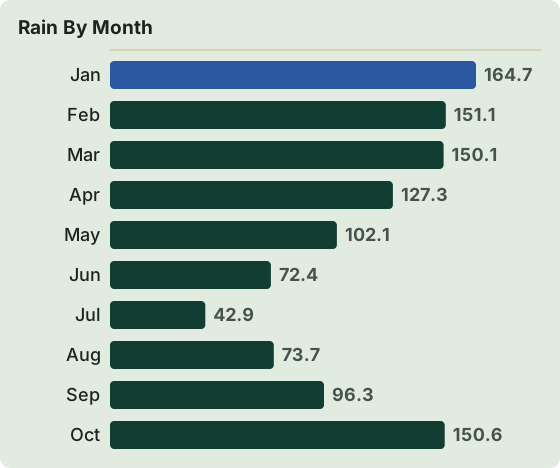
The character of the ground matters more than the map distance. Karst limestone drinks the rain straight down, so streams that look permanent on a map are often dry in July, and the FHMZ 1961-1990 station series for Mostar shows why: July averages just 42.9 mm of rain against 200.0 mm in November. That single contrast explains the landscape, the heat and the water-carrying rule in one line. The same valley heat that makes Mostar's riverside terraces pleasant at 21:00 makes a midday ascent of Hum punishing by late morning.
Two practical anchors frame every walking plan here. First, Mostar is an inland city on the Neretva with no sea coast, so a "hike and swim" day means rivers and lakes, not beaches, and the Neretva is cold even in August. Second, rural Herzegovina carries mine-suspected areas from the war, so every walk outside town runs on marked paths, as covered in the safety section below.
Can You Hike Up Hum Hill From Central Mostar?
Yes, Hum is the one true walking summit you can start from the Old Bridge: the hill with the large summit cross rises directly above the north bank of the Neretva, and the climb is steep, exposed, unshaded and best started early, because ERA5 reanalysis, 1991-2020 puts July mean daily highs at 29.9 C and August at 30.5 C in the valley below it. There is no through road over the top, no cafe and no water on the way up, so treat it as a self-sufficient half-morning: boots or firm shoes, a litre or more of water per person, sun protection, and a start at or before sunrise if you are walking in summer. The reward is the single clearest overview of the whole city, the Neretva's loop through it, and the ridgelines to the east and west.
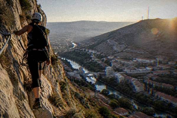
The west-bank counterpart is the Fortica ridge, which sits above the Old Bridge and carries a viewpoint complex reached from the edge of the Mostar Old Town. Fortica is less a mountain and more a hillside park with a big panorama, which makes it the safer choice for a hot afternoon or for families: the profile is gentler, the surface is better, and the views take in Stari Most itself rather than the city as a whole. A structured way to reach it, with street-art stops on the climb, is the guided Skywalk Fortica route; a rockier option is the via ferrata on Hum, described in the guided-options section below.
The pattern for both hills is the same as for everything in this guide: go early, carry water, and get off the stone by early afternoon. The FHMZ 1961-1990 absolute maximum for July is 41.2 C, and even in April the absolute record is 30.8 C. Limestone holds that heat and gives it back all evening.
If a day of climbing in full sun sounds like the wrong holiday, the river is the obvious counterweight: a Neretva kayak safari spends its hours on cold water below the hills instead of on top of them.
Where Do Velež And Podveležje Fit Into A Mostar Hiking Trip?
Velež is the big mountain massif east of Mostar and Podveležje is its high plateau of villages, summer pastures and stone-walled lanes, together forming the proper mountain day out from the city, reached by car or tour rather than on foot from the centre, because the terrain climbs from the valley into open, waterless karst upland with long gravel roads between trailheads. Podveležje is the gentler half: rolling plateau country where walks link hamlets, springs and viewpoints over the whole Neretva valley. Velež proper is the serious half, with rough paths, real altitude and weather that can change fast even when Mostar below is baking.
This is the part of a Herzegovina walking trip where the climate tables flip. The valley floor bakes, but the plateau and the high ridges run noticeably cooler, and November's 200.0 mm of rain (FHMZ 1961-1990) arrives up here as wind, fog and sometimes the first snow, while the same month down in Mostar is merely grey. Plan mountain days for June through September, carry a layer even in August, and treat any weather forecast for "Mostar" as a valley forecast, not a summit one.
Access is the practical question. The plateau villages sit east of the city behind Hum, and the trailheads for the bigger Velež routes are further still, on roads where a hire car (see Mostar car rental) or a local driver saves hours. There is no public transport that serves mountain trailheads, so the honest options are: drive yourself, hire a transfer, take a guided day that includes the driving, or build the trip around one of the Herzegovina day tours that climb onto the plateau. Guided options that pair the outdoors with the driving include the Skywalk Fortica and street art tour, which covers the city-side hill with a zipline option.
For walkers who want rock rather than track, Hum also carries a via ferrata, a cabled climbing route on the hill directly above the city, run as a guided experience with equipment: the Via Ferrata Hum climb is the structured way onto it, and it is the one near-city route where going with a guide is not optional but the product itself. Check availability
What Does The Climate Mean For A Walking Season Near Mostar?
The walking season around Mostar runs roughly April through June and September through October, because midsummer heat in the valley is the real constraint: ERA5 reanalysis, 1991-2020 gives July a mean daily high of 29.9 C and August 30.5 C, while FHMZ 1961-1990 shows July with only 5 days of rain over 1 mm and November with 200.0 mm of rain across 11 such days. Spring and autumn carry the same stone, the same views and far kinder temperatures, and the shoulder months also carry the year's clearest walking light.
| Month | Mean daily high C (ERA5 1991-2020) | Mean daily low C (ERA5 1991-2020) | Rain mm (FHMZ 1961-1990) |
|---|---|---|---|
| Jan | 8.4 | 0.2 | 164.7 |
| Feb | 9.7 | 0.3 | 151.1 |
| Mar | 13.4 | 3.3 | 150.1 |
| Apr | 17.7 | 7.0 | 127.3 |
| May | 22.3 | 11.4 | 102.1 |
| Jun | 26.8 | 15.3 | 72.4 |
| Jul | 29.9 | 17.7 | 42.9 |
| Aug | 30.5 | 18.1 | 73.7 |
| Sep | 24.5 | 14.0 | 96.3 |
| Oct | 19.5 | 9.8 | 150.6 |
| Nov | 14.1 | 5.7 | 200.0 |
| Dec | 9.3 | 1.4 | 178.7 |
Read the table as a planning tool, not a forecast. The ERA5 columns are modelled climate normals for the grid cell over the valley, and the FHMZ column is the 1961-1990 station series for Mostar itself; the valley floor can run hotter than the modelled figure on a still afternoon, and the hills above run cooler on any afternoon. Winter walking is possible on the plateau in a mild spell, but the same karst that bakes in July turns icy and slick in January, when absolute minimums reach -10.9 C in the station record.
For a fuller month-by-month picture of visiting conditions rather than trail conditions, the site's Mostar weather and best time to visit Mostar pages carry the detail.
Is It Safe To Hike In Rural Herzegovina?
The one non-negotiable rule for rural walking around Mostar is to stay on marked paths and used roads, because parts of Herzegovina remain mine-suspected areas from the war, and the national mine-action centre (BHMAC) maintains the suspected-area data that walkers should respect; on top of that, carry water, sun protection and a charged phone, note the emergency number 112, and do not rely on streams for drinking water on karst. This is standard countryside practice in Bosnia and Herzegovina, not a reason to stay in town: Hum's lower slopes, Fortica, the plateau lanes around villages and the marked routes used by local operators are all walked regularly. The rule bites at the edges: abandoned terraces, old front-line scrub and any path that fades into unwalked ground.
| Risk | Where It Applies | What To Do |
|---|---|---|
| Mine-suspected areas | Off-path scrub and abandoned land in rural Herzegovina | Stay on marked paths and used tracks; respect warning signage |
| Heat | Valley and south-facing slopes, July and August | Start at dawn; carry ample water; finish by midday |
| Dry karst terrain | All routes; no reliable surface water | Carry all the water you will drink; treat map streams as dry |
| Slick limestone after rain | All stone paths, especially in winter | Firm footwear; walk autumn and spring rather than after rain |
| No mobile coverage on parts of the plateau | Velež and Podveležje back country | Tell someone your route; carry offline maps |
Three emergency numbers are worth having in the phone: 112 as the general number, 122 for police and 124 for ambulance. They are reported as the standard Bosnian emergency numbers, and 112 will route you if you remember no other. There is no mountain-rescue fee structure or registration system to print here, so simply leave your plan with your accommodation and keep to routes you can describe to someone else.
If the open-country rules feel like a lot for a first visit, the guided structure solves it: local operators run the countryside days with route-finding, water stops and transfers built in, and the Bosnia and Herzegovina travel tips page carries the wider practical picture for the country.
What Should You Pack For A Mostar Hiking Day?
Pack for dry heat and sharp stone: a litre or more of water per person for Hum and two for anything longer, broken-in shoes with grip rather than trainers, a hat and high-factor sun cream, a windproof layer for the plateau where it is always breezier than the valley, and offline maps plus a power bank for the stretches of the plateau with no phone signal. Trekking poles earn their weight on the limestone descents, which are steeper and looser than the climbs, and a buff or scarf does double duty against dust and, outside summer, against the plateau wind.
Two local quirks are worth the weight of a paragraph. First, the currency is the convertible mark (KM, BAM), pegged at 1 EUR = 1.95583 KM, and euro cash is often accepted in tourist areas at a rounded rate you should confirm before paying; a plateau farmhouse or village shop may well be cash-only, so carry marks in small notes. Second, a tourist tax is reported at 3 KM per person per night in Herzegovina-Neretva Canton from 1 January 2026, usually collected through your accommodation, so confirm at booking rather than being surprised by the line on the bill. Money details sit on the Mostar money page.
Timing matters as much as kit. A dawn start in July puts you on Hum's summit by 08:00 with the city still in shadow below you, and back at a cafe table before the stone starts radiating. The same route at 13:00 in August is a different, dumber walk. Plan around light, not around a clock: midsummer days give you from about 05:00, and walking the cool half of the day is the single biggest upgrade available to a hiker in this valley.
What Water And Lake Days Pair With Hiking Near Mostar?
The cold-water pairings for a walking trip are the Neretva river itself, which stays cold even in August because it is karst spring-fed, and a ring of lakes at driving distance, including Boračko jezero at 89.9 km and about 113 minutes by road from Stari Most, plus the Kravica waterfall pool at 55.2 km and about 54 minutes, where summer swimming is allowed in the designated area with no lifeguard reported. None of these is a swimming-pool experience: the Neretva near Mostar runs cold in summer, and Kravica's pool is a river-fed basin under a tall band of falls. That is precisely the appeal after a hot morning on stone.
| Water spot | Road distance from Stari Most | Drive time (free-flow) | Notes |
|---|---|---|---|
| Neretva river (city stretch) | 0 km | 0 min | Cold even in August; kayak tours run here |
| Kravica waterfall pool | 55.2 km | about 54 min | 20 KM adult entry all year; designated swim area; no lifeguard reported |
| Hutovo blato park | 48.1 km | about 62 min | Boat trips reported around 20 KM; birdlife park |
| Boračko jezero | 89.9 km | about 113 min | Mountain lake below the Prenj approaches |
The kayak option deserves a special mention for hiking trips, because it is the one water day that needs no car: the Neretva kayak safari runs on the river within reach of the city, so a week in Mostar can pair a dawn Hum climb with an afternoon on flat, cold water and never touch a steering wheel. Check availability
For fuller coverage of the swimming question in and around the city, the site carries a dedicated piece on whether you can swim in the river at Mostar, and the Kravica waterfall page has the full entry-price and monthly-hours breakdown, including the fact that the park is open all year with hours that change by month.
How Far Can You Go From Mostar For A Mountain Day?
The high-country day trips from Mostar reach from Blagaj's fortress ridge at 13.9 km and about 20 minutes by road to Trebinje at 116.5 km and about 142 minutes, with the classic mountain towns and lakes spread between, so a car-based week can walk a different massif every day while sleeping in the same Mostar bed. The table below lists the driving figures from Stari Most, computed free-flow with no border queues; several of these destinations also run as organised day tours from the city, which removes the driving question entirely.
| Destination | Road km from Stari Most | Drive time (free-flow) | Walking character |
|---|---|---|---|
| Stjepan-grad fortress, Blagaj | 13.9 | about 20 min | Short steep ruin climb above the Buna spring |
| Blagaj Tekke | 13.7 | about 19 min | Riverside walks at the Buna headwater |
| Počitelj | 30.0 | about 31 min | Fortified village lanes and tower stairs |
| Radimlja necropolis | 33.5 | about 42 min | Short walk among UNESCO-listed stećci |
| Hutovo blato | 48.1 | about 62 min | Flat wetland trails and boat trips |
| Jablanica | 47.4 | about 57 min | Neretva canyon; lake shore |
| Boračko jezero | 89.9 | about 113 min | Mountain lake, base for Prenj approaches |
| Trebinje | 116.5 | about 142 min | Old town, river and hillside monastery walks |
Two of these deserve a hiker's note. Stjepan-grad, the fortress ridge above Blagaj, is the shortest proper climb on this list: a ruined hilltop fort looking straight down at the Buna spring, close enough to walk up before breakfast in Blagaj and still be back in Mostar for lunch. And Boračko jezero is the practical gateway for anyone eyeing the Prenj range, the high mountains south-east of Mostar that give this page half its title: Prenj is a committed alpine proposition with huts and long approaches, not a day walk, but the lake is where its access roads begin. The Herzegovina road trip page strings the whole region together for drivers.
If the driving itself is the deterrent, organised countryside days cover the same geography: the Discover Herzegovina day tour links Kravica, Blagaj and Počitelj, and the sibling Herzegovina day tour from Mostar does the loop with a private car and live guide. Check availability
Common Questions About Hiking Near Mostar
Can you hike from Mostar Old Town without a car?
Yes, for the city hills. Hum and the Fortica ridge both start from streets you can walk to from Stari Most, and the Neretva kayak safari runs from the river in the same way. Everything bigger, on Velež, Podveležje or around Prenj, needs a car, a transfer or a guided day.
How hot is hiking in Mostar in summer?
ERA5 reanalysis, 1991-2020 gives July a mean daily high of 29.9 C and August 30.5 C for the valley, and the FHMZ 1961-1990 absolute maximum is 41.2 C in July. Dawn starts and finishing by midday are the standard summer pattern.
Are there marked trails around Velež and Podveležje?
The plateau has village-to-village lanes and used tracks walked by local operators, and the bigger Velež routes are proper mountain paths. Route-finding on karst is easier with a guide or offline maps; there is no public transport to any trailhead.
Is the water safe to drink on hikes near Mostar?
Treat all surface water as unreliable on karst and carry everything you plan to drink.
What is the best month for hiking near Mostar?
May, June and September: rain is moderate (72.4 to 102.1 mm per month, FHMZ 1961-1990), mean daily highs sit between 22.3 and 26.8 C (ERA5 1991-2020), and the high ground is clear of winter conditions.
Can you combine hiking with swimming near Mostar?
Yes. Kravica waterfall (55.2 km, about 54 minutes by road) allows summer swimming in the designated pool area with no lifeguard reported, and the Neretva itself is a kayaking river, cold even in August.
Walking country this dry rewards early starts and honest water planning, and it gives back the clearest views in Herzegovina for the trouble. Fit the hills around the city first, keep to the marked paths beyond it, and let the Mostar Travel Guide planning pages handle the beds, the seasons and the drives.